
"distribution map"
200 article(s) found
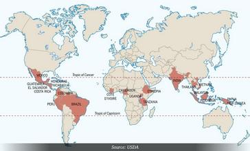
The World Coffee Map explains in detail the specific distribution points and geographical names of the world coffee map.
Costa Rican coffee has full grains, ideal acidity and unique strong aroma. Tarrazu of Costa Rica is one of the major coffee producing areas in the world. Costa Rica, with its fertile volcanic soil and good drainage, is the first country in Central America to grow coffee and bananas for commercial value. Coffee and bananas are

An important step in coffee tasting: tongue taste map
Coffee taste must read-tongue taste distribution map (brief note: before sweet and after bitter edge acid-base)
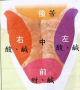
Coffee tasting skills for drinking Coffee Taste Map of tongue
Coffee taste must read-tongue taste distribution map (brief note: before sweet and after bitter edge acid-base)
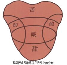
Correct the taste distribution of the tongue Coffee tongue Taste training Coffee Flavor characteristics
Scientists have found that the "tongue taste distribution map" mentioned in the previous cup test textbook needs to be revised. Although these textbooks point out the approximate position where the tongue accepts sweet, sour, salty and bitter taste, this classification may not be suitable for everyone. In fact, the human tongue is actually a receptor for a comprehensive sense of taste, and everyone has a variety of tastes.
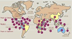


Tongue taste distribution map
Remember: before the sweet and the bitter side of the acid-base.

Coffee tasting related: is there really a "taste map"?
Truth: the idea of a taste map has been around for decades. In fact, the cells that distinguish all kinds of taste exist in every taste bud, and the taste buds are distributed on the surface of the tongue and in the mouth, that is to say, the area with taste buds on the tongue can sensitively distinguish all taste senses. The rumored taste map does not actually exist. This textbook rumor actually comes from
Where are the main coffee producing areas in the world | introduction to the distribution map of coffee belt in coffee bean producing areas
Professional coffee knowledge exchange more coffee bean information please follow the coffee workshop (Wechat official account cafe_style) 1, Asia 1. Indonesia (Indonesia) famous representative coffee: Java (Java), Sumatra Manning (SumatraMandheling)
About Coffee World Map
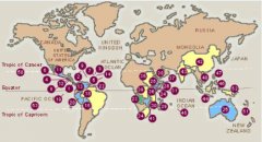
COFFEE WORLD MAP Most coffee production areas are located between the Tropic of Cancer, that is, 25 degrees north of the equator and 30 degrees south of the equator in the tropics or subtropics. Areas with an annual average temperature of 16-25 degrees Celsius, frost-free and rainfall of 1600-2000 mm. At present, there are more than 70 major coffee producing countries, and the Greater China is located at an altitude of 300-400 meters.

Coffee Belt (COFFEE WORLD MAP) Coffee trees grow around the equator
Coffee trees grow in tropical or subtropical agricultural gardens centered around the equator and called coffee belts. Most of the coffee production is between the Tropic of Cancer, 25 degrees north of the tropical or subtropical equator and 30 degrees south of the equator. An area with an annual average temperature of 16-25 degrees Celsius, no Frosts Descent and rainfall of 1600-2000 mm. At present, coffee is mainly produced by seven countries.

Coffee Belt (COFFEE WORLD MAP) Coffee beans are generally grown at what latitude?
Most of the coffee production is between the Tropic of Cancer, 25 degrees north of the tropical or subtropical equator and 30 degrees south of the equator. An area with an annual average temperature of 16-25 degrees Celsius, no Frosts Descent and rainfall of 1600-2000 mm. At present, coffee is mainly produced in more than 70 countries. The Big self is located at an altitude of 300,400m, sometimes between 2000 and 2500 meters above sea level.
Coffee belt (COFFEE WORLD MAP)
Coffee trees grow in tropical or subtropical agricultural gardens centered around the equator and called coffee belts.
The World Map of Fine Coffee beans-- Latin American Coffee
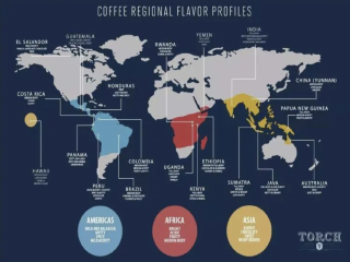
1. Representative varieties of Jamaica 2, Cuba 3, Mexico 4, Costa Rica 5, Brazil 6, Colombia 7, Panama 8, Peru 9, Guatemala 10, El Salvador 11, Honduras and other Latin American countries.
The World Map of Fine Coffee beans-- African Coffee
1. Kenya 2, Ethiopia 3, Angola 4, Zimbabwe 5, Tanzania 6, Uganda
Coffee common sense what is a coffee belt (COFFEE WORLD MAP)
Coffee trees grow in tropical or subtropical agricultural gardens centered around the equator and called coffee belts. Most of the coffee production is between the Tropic of Cancer, 25 degrees north of the tropical or subtropical equator and 30 degrees south of the equator. An area with an annual average temperature of 16-25 degrees Celsius, no Frosts Descent and rainfall of 1600-2000 mm. At present, coffee is mainly produced by seven countries.
Boutique Coffee Science detailed explanation of Coffee Belt (COFFEE WORLD MAP)
Coffee trees grow in tropical or subtropical agricultural gardens centered around the equator and called coffee belts. Most of the coffee production is between the Tropic of Cancer, 25 degrees north of the tropical or subtropical equator and 30 degrees south of the equator. An area with an annual average temperature of 16-25 degrees Celsius, no Frosts Descent and rainfall of 1600-2000 mm. At present, coffee is mainly produced by seven countries.

Tanzania Coffee Bean introduces the geographical location of Tanzania
Location Map of Tanzania Tanzania covers an area of 945087 square kilometers, of which Zanzibar is 2657 square kilometers. It consists of the mainland, Zanzibar and more than 20 small islands. Located in eastern Africa and south of the equator, the continent is bounded by the Indian Ocean to the east, Zambia, Malawi and Mozambique to the south, Rwanda, Burundi and the Democratic Republic of the Congo to the west, and Kenny to the north

A map of the distribution of branches across the country which cities have Nanjing that will be closed after half an hour of opening
In April 2021, the tea brand in Changsha, Hunan, which has always been remembered by the people all over the country, finally stepped out of Hunan Province and came to Guangdong.